Ordnance Survey Benchmark
A small, easily missed cut mark on the tower wall records Winterton church’s place in one of Britain’s earliest precise surveys.
These photographs should help you pinpoint where, on the outside of the church building, to look for this bench mark. It is on the north-west angle of the tower, on the west wall between the window and the door leading into the tower. It is an Ordnance Survey bench mark, cut between 7 August 1851 and 27 August 1857.
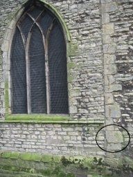
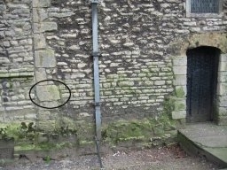
When the Ordnance Survey began to make their first maps of Britain, they used a method called ‘triangulation’, based on simple geometry, which allowed them to fix the height above sea level for a number of locations. At each of these places a bench mark was cut as a record of the exact spot for future reference. One of the key lines of survey in the ‘First Primary Levelling, England & Wales’ went from Swineshead – Boston – Wainfleet – Sutton – Grainthorpe – Great Grimsby – Barton-upon-Humber – Adlingfleet – Rawcliffe, with several branches (side levels) off this main line. The Winterton church benchmark was one of these.
The surveyor’s record stated: “Winterton Church. Mark on North-west angle of tower; 2.74 ft. above surface.” The bench mark was levelled with a height of 92.7590 feet (28.2729 metres) above mean sea level (Liverpool datum). Other bench marks were placed in Earlsgate and Roxby Road in Winterton, and at Coleby and West Halton. Bench marks of this kind are recorded on specialist bench mark databases and on the Ordnance Survey’s own levelling records.
A log entry for Winterton Church gives details of the bench mark on our church: logged on 29th June 2008, condition “slightly damaged — cut mark and bolt severely weathered.” When you walk in through the main church gate, follow the tower wall to the far end to find it.